Botany: An Introduction to Plant Biology - Mauseth, James D. 2017
Ecology
Biomes
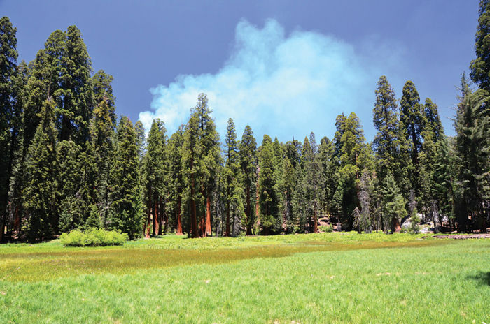
Chapter Opener Image: Subalpine forests occur on mountains at elevations high enough to be cool and moist but not so high that it is too cold for trees to survive. Subalpine forests may be temporarily hot and dry for a few weeks in summer, and often the plants experience occasional water stress because soil at high altitudes is too thin and rocky to hold water from rainfall or snowmelt for more than a few weeks. The trees here with orange bark are giant redwoods, Sequoiadendron giganteum.
OUTLINE
✵ Concepts
✵ World Climate
- Effects of Earth’s Tilt
- Atmospheric Distribution of Heat
- Oceanic Distribution of Heat
✵ Continental Drift
- Present Position of the World’s Continents
- Past Positions of the World’s Continents
✵ The Current World Biomes
- Moist Temperate Biomes
- Dry Temperate Biomes
- Polar Biomes
- Tropical Biomes
Box 27-1 Botany and Beyond: Measuring Ancient Continental Positions and Climates
LEARNING OBJECTIVES
After reading this chapter, students will be able to:
✵ Define biome and note the two factors with the greatest influence on biome location.
✵ Explain the climatic effects of Earth’s tilt, atmospheric distribution of heat, and oceanic distribution of heat.
✵ Restate how past and present positions of the continents affect climate.
✵ Describe the moist temperate, dry temperate, polar, and tropical biomes of North America and what influences each one.
 Did You Know?
✵ Biomes such as tropical rain forests are sets of particular types of plants in particular climates. The actual species vary from one rain forest to another but the types of plants are the same.
✵ Our common words “desert,” “forest,” “grassland,” “marsh,” and so on are remarkably accurate for naming several important biomes.
✵ If Earth’s axis of rotation were vertical and its orbit perfectly circular, we would have no seasons.
✵ Circulation in the atmosphere and oceans not only moves massive quantities of material but it also moves heat.
![]() Concepts
Concepts
Earth’s land surface is covered almost entirely by biomes, extensive groupings of many ecosystems characterized by the distinctive aspects of the dominant plants. For example, some of the biomes of North America are the temperate deciduous forests, subalpine and montane coniferous forests, grasslands, and deserts. Plant life is absent only in the harshest deserts (the Atacama in Chile and Peru, the Sahara in Africa, the Gobi in China) and in the land regions covered permanently by ice (most of Antarctica and the tops of high mountains; FIGURE 27-1). In all other areas, the rock and soil are at least temporarily free of ice and have some liquid water; primary producers—plants, algae, and cyanobacteria—carry out photosynthesis and support food webs of consumers and decomposers.
Biomes vary from extremely simple, as in tundra, to more complex grasslands, temperate forests, and tropical rain forests. Biome complexity and physiognomy are most strongly influenced by two abiotic factors: climate and soil. A particular type of biome, such as grassland or temperate deciduous forest, may occur in various regions of Earth because the same set of climatic and soil factors occurs in various regions. At all sites, the physiognomy—the appearance—of a biome is similar, but often the actual species present differ considerably from one area to another. For example, temperate grasslands are easily recognizable in the central plains of the United States, the steppes of Russia, the pampas of Argentina, and the veldt of Africa (FIGURE 27-2); all are dominated by grasses and large mammals and are devoid of trees except along rivers. Species that become adapted to the grassland niche of one continent do not occur on other continents because no birds, mammals, winds, or other means carry seeds such long distances. Despite the lack of gene flow between widely separated units of a biome, the physiognomic similarity persists as a result of convergent and parallel evolution: Climate, soil, and other habitat factors in each area select for similar phenotypes. If portions of a biome are not too widely separated, they will actually have some species in common.
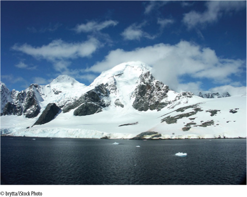
FIGURE 27-1 Antarctica is one of the few places on Earth where plant life simply cannot exist; in the area shown, even if plants were introduced, they would die.
The geographic locations of the Earth’s biomes are determined by many factors, but two of overriding importance are (1) world climate and (2) positions of the continents. If either or both of these factors were different, the locations of the biomes would be different. It is important to realize that both do change: Climate undergoes cycles of cooling and warming, and continents shift position because of continental drift. In the past, conditions on Earth’s surface were quite different and so were the distributions of plants and animals. Similarly, the conditions will be altered in the future, and organisms will be affected by that as well.
![]() World Climate
World Climate
Earth’s climatic conditions are the result of its tilted axis of rotation and the presence of the atmosphere and oceans.
Effects of Earth’s Tilt
Imagine a planet whose axis of rotation is exactly perpendicular to the plane of its orbit. At the equator, the sun would rise exactly in the east every day of the year; it would pass directly overhead and set in the west. There would be no change, no seasons. At all sites not on the equator, 70 degrees N for instance, the sun would never be overhead; every day it would rise in the southeast, pass low in the sky, and set in the southwest. Maximum heating would be at the equator; all other regions would always receive only oblique lighting and would be much cooler. If there were no atmosphere or oceans, heat could not be transferred from the equator to the poles, and there would be a tremendous temperature gradient between those regions.
Earth’s axis of rotation is tilted 23.5 degrees away from perpendicular to the orbital plane. At summer solstice, June 21 or 22, the North Pole points as directly toward the sun as possible, and in the Northern Hemisphere, the sun has reached its highest point in the sky. The sun appears to be overhead at noon for those people located at 23.5 degrees N latitude, the Tropic of Cancer, which runs just south of California, Texas, and Florida. The days are their longest, and summer has officially begun. North of the Arctic Circle, the sun is visible even at midnight.
As Earth continues its orbit, the axis of rotation points less toward the sun, which appears to rise and set more to the south and is lower in the southern sky at noon. By September 23, autumnal equinox, Earth has made one-quarter orbit. The sun is directly over the equator, and days are exactly 12 hours long: Autumn begins. After another 3 months, winter solstice, December 21 or 22, the South Pole points as directly as possible toward the sun; the sun is directly over the Tropic of Capricorn, 23.5 degrees S latitude. Summer begins in the Southern Hemisphere, but in the north, winter begins and days are at their shortest; above the Arctic Circle, the sun never rises. With another one-quarter orbit, the sun moves back toward the equator, arriving there at March 21, the vernal equinox.
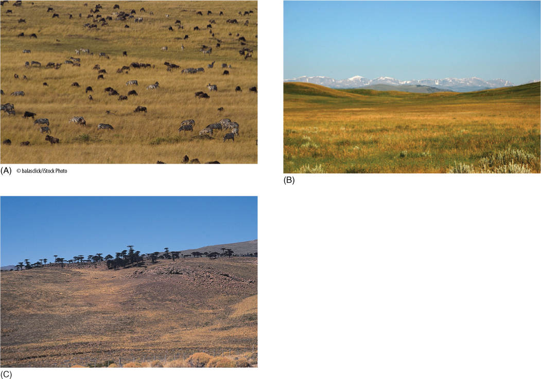
FIGURE 27-2 Under the proper conditions of climate and soil, grasslands almost invariably develop, as opposed to a rain forest or desert. Wherever those conditions exist, a specific type of vegetation can be expected. Even though the actual species present in one differ from those in the other, the biomes are still recognizable as grasslands because of convergent evolution due to similar environmental conditions. Grasslands in (A) Masai Mara, Kenya Africa; (B) Gillette, Wyoming; and (C) Argentina.
The most intense solar heating moves seasonally northward, then southward. All parts of the planet experience seasonality, although in the region between 23.5 degrees N and 23.5 degrees S, the tropics, not as much change occurs between summer and winter as in the temperate regions outside this band.
Atmospheric Distribution of Heat
The atmosphere and oceans, being fluids, develop convection currents and massive flows when heated in one area and cooled in another. They distribute heat from the tropics to the temperate regions and all the way to the poles.
Much of the tropical zone is occupied by the Pacific, Atlantic, and Indian Oceans (FIGURE 27-3). Throughout the year, the water and air receive solar heat, causing tremendous amounts of evaporation. The air warms, expands, then rises high into the atmosphere. As it flows upward, the surrounding air pressure decreases, and the moist rising air expands even more. This expansion causes the air to cool, decreasing its ability to hold moisture. Water vapor condenses into rain and falls back to the surface in torrential storms, producing tropical rain forests in Central America, northern South America, central Africa, and Southeast Asia.
After rising, the air is pushed northward and southward by the continued rising of more tropical air below it (FIGURE 27-4). While spreading at high altitude, air radiates heat to space, cooling even more. By the time it reaches about 30 degrees N or S latitude (the horse latitudes), it has cooled, contracted, and become dense enough to sink. It encounters greater atmospheric pressure at lower altitudes and is compressed and heated. As it warms, its water-holding capacity increases. Because its capacity to hold water is greater but its water content is the same, the air becomes drier. But it had already lost much of its moisture while initially rising, so it is now extremely dry. Land areas below this descending air contain the world’s hot, dry desert biomes (Figure 27-3).
Once back at Earth’s surface, part of the air spreads toward the equator and part flows toward the poles. Earth’s rotation causes the air moving toward the equator to be deflected westward. It moves as a northeast trade wind in the Northern Hemisphere and a southeast trade wind in the Southern Hemisphere. Air spreading toward the poles from the horse latitudes is deflected eastward and blows as a prevailing westerly.
The actual area of descending dry air varies with the season, being farther north when the sun is near the Tropic of Cancer (Northern Hemisphere summer) and farther south when the sun is near the Tropic of Capricorn. The United States, during its winter, is located entirely within the influence of the prevailing westerlies; winter weather comes from the Pacific and Arctic Oceans, moving eastward across the continent. During summer in the United States, the northeast trade winds have moved northward far enough to influence the states along the Gulf of Mexico; northeast trade winds bring summer storms westward from the Atlantic onto the east coast and gulf, supplying summer rains.
FIGURE 27-3 Most land on Earth is distributed rather far north at present, and the tropical zone, between the Tropics of Cancer and Capricorn, is mostly water. The greatest amount of solar energy falls on water, causing great evaporation and humidifying the atmosphere but leading to relatively little temperature change. If more land were in the tropics, the soil would heat more, which in turn would heat the air, but the oceans would stay cool and evaporate little moisture to the atmosphere; all regions would receive much less rain.
Continental Climate
The size of a land mass influences the weather it receives. Larger islands such as the Hawaiian Islands, Guam, and Puerto Rico have mountains that force air to rise as it blows across them. Rising air cools, and rain forms. Low-lying, small islands such as the Florida Keys and the smallest islands in the Bahamas are too flat to affect the air; these desert islands are extremely dry, often with no fresh water streams or lakes (FIGURE 27-5).
Continents also cause air to rise, cool, and drop precipitation. If the topography is fairly flat, air rises gradually, and rains are distributed over an extensive area. Summer storms from the Atlantic and Gulf of Mexico move through the eastern United States, the Mississippi Valley, and the plains states; the land rises so gradually that rainfall covers half a continent.
If topography is mountainous, as on the United States’ west coast, rain is dropped in a narrow area. The prevailing westerlies bring moist air from the Pacific Ocean onto land over California, Oregon, Washington, Mexico, and western Canada. Air is immediately forced to rise by coastal mountain ranges; strong rains fall on the western slopes. After the air crosses the summit, however, it descends and warms, and rains cease. The eastern slopes are much drier than the western ones. The decreased rain on the landward side of mountains is called a rain shadow. As air continues eastward, it encounters the Sierra Nevadas and the Rocky Mountains and is forced upward again, and more rain falls. Descending east of the Rockies, rains cease, and the air moves across the central plains and only rarely provides precipitation.
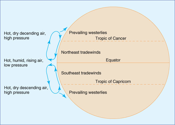
FIGURE 27-4 Air rises above the equator and then spreads northward and southward at high altitudes. By the time it has reached the tropics, it is cool enough to contract, become dense, and sink. At the surface, some flows back toward the equator as trade winds, and some continues toward the poles as prevailing westerlies.
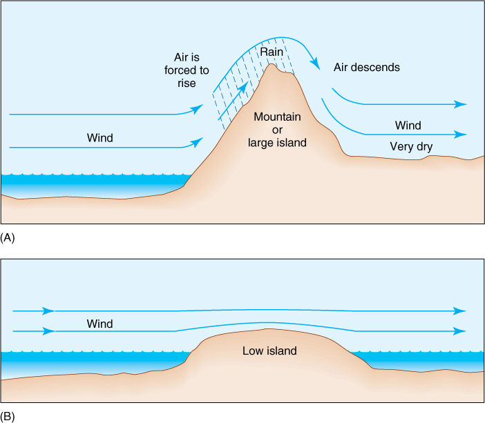
FIGURE 27-5 (A) When a mountain or other large land mass forces air to rise, the air cools below its dew point and drops rain or snow. On the lee side, descent of the air compresses and heats it, raising its ability to hold water. Rather than bringing rain to the area, it may actually dry out the soil. (B) Air blows undisturbed across low islands; therefore, they receive little rain even though the air may be extremely humid.
During our summer, tropical storms sweep west through the Caribbean and then turn to the north or northeast and bring moisture inland as far west as central Texas and north toward the Great Lakes. Fortunately, no southern coastal mountain range blocks this movement or else the central and eastern United States would be very dry.
The size of a land mass also affects its temperature fluctuation. On a large island, moist air is always rising over the mountains, and clouds are frequent. Temperatures have a narrow range. Along the coasts of a continent, cloudy, rainy weather is frequent, and temperature fluctuation is mild. Farther inland, air is dry and clear; a lack of clouds exposes the land to full daytime insolation, and heating is rapid and extreme. At night, clear skies allow the land to radiate infrared energy into space, with none reflected by clouds; cooling is also rapid and extreme.
Oceanic Distribution of Heat
Air circulation patterns drive water in the Pacific Ocean and Atlantic Ocean basins in four giant circular currents, clockwise in the Northern Hemisphere and counterclockwise south of the equator. Ocean currents distribute heat from the tropics to the poles, lessening the temperature gradient that would otherwise exist. Also, as warm tropical surface water moves to higher latitudes, large amounts of water evaporate into the temperate prevailing westerlies, giving them more humidity than they would have if the oceans did not circulate.
As trade winds blow across the tropics from east to west, they push surface waters into equatorial currents. During the weeks that a particular mass of water flows along the equator as part of the Atlantic Equatorial currents, it absorbs huge amounts of energy and warms significantly. At the western side of the ocean basin, it is deflected northward by the tip of Brazil, and then part is deflected by Florida and enters the Gulf of Mexico. The water’s warmth permits high evaporation into the air and keeps much of the gulf coast humid. The rest of the current moves along the east coast as the Gulf Stream; because this is a latitude that is dominated by westerly winds, the warm current does not keep the land as warm and wet as one would expect. Near New Jersey and New York, the current turns eastward toward Europe; at the turning point, cold polar water moves south along the east coast of Canada and the northeastern United States.
The Pacific Ocean has a similar pattern with westerly equatorial currents. The Philippines and Indonesia act as a barricade, deflecting water north and south. Much northern water heads northward then eastward as the Kuro Shio current toward Canada and Washington. Once at the west coast of North America, some water turns northward toward Alaska as the Alaska current, but the bulk turns south as the California current. The westerly winds absorb huge amounts of moisture as they blow for thousands of miles across the warm Pacific waters, and even though much falls as rain over the ocean, a large amount remains in the air and keeps the coasts wet.
![]() Continental Drift
Continental Drift
Present Position of the World’s Continents
One of the most important factors in determining the climate of a region is that region’s latitude. Near the equator in the tropical zone, climate is warm and humid, but a region located either to the north or south is exposed to cooler, drier conditions (Figure 27-3).
If the continents occupied different positions, they could cause the entire Earth to have an altered climate. The presence of the large continent of Antarctica at the South Pole allows huge amounts of fresh water to accumulate there as snow fields and glacial ice, lowering sea levels and exposing more land surface. It also increases ocean salinity by trapping fresh water for thousands of years. If Central America did not exist, water could circulate between the Pacific and Atlantic Oceans, resulting in new oceanic circulation patterns that would affect heat distribution to the poles.
If a continent is small and flat, moist oceanic air can blow across it and bring precipitation to all parts. If it is large and flat, the central regions are too far from the oceans to receive much moisture, most of it having fallen as rain or snow closer to the coastline. The center of the giant continent of Eurasia suffers this fate. Mountains create rain shadows if located on the side of the continent close to the source of wind. The United States would be moister if its highest mountains were in the east or if it were located farther south where the northeast trade winds could bring moisture in across the low Appalachians and Adirondacks.
Past Positions of the World’s Continents
Cambrian Period
During the Cambrian Period, while all life was still aquatic and nothing lived on land, several separate continents were distributed in a vast ocean. Eurasia consisted of either one continent or two that were already close and moving together; the collision of western Europe with eastern Europe and Asia caused the formation of the Ural Mountains. This ancient land mass, whether one or two continents, was also farther south than at present, located in a warmer climate. In the Southern Hemisphere was a giant continent called Gondwanaland; it was composed of South America, Africa, India, Australia, and Antarctica. Gondwanaland was constructed such that South America and Africa were attached, and Brazil and northwest Africa were located at the South Pole. The rest of the continent extended northward toward the tropics, but on the opposite side of the world from North America and Eurasia.
Middle and Late Paleozoic Era
At about the time life was beginning to move onto land and rhyniophytes were evolving, the continents drifted together (FIGURE 27-6A). First, during the Silurian Period, North America collided with Eurasia, forming the Appalachian Mountains, which have almost entirely eroded away in the intervening 400 million years. This new continent is known as Laurasia. Next, Gondwanaland moved north and ran into Laurasia, pushing up the Alps. Virtually all land on the entire globe was located together as one supercontinent, Pangaea. The Laurasian portion was still in the tropics, and much of Gondwanaland was in the southern temperate and polar regions.
Pangaea, which existed for millions of years, through the end of the Paleozoic Era, had a diverse climate. The Laurasian portion was warm, moist, and tropical, whereas southern Gondwanaland was frozen and heavily glaciated. Large regions were swampy lowlands. Initially, Pangaea must have been relatively flat, but the collisions caused the formation of extensive mountain ranges in its center: the Appalachians and the Urals, as just mentioned. These must have caused rain shadows in the interior of Pangaea, and its enormous physical dimensions would have caused the central regions to be dry anyway. It was in the diverse conditions of Pangaea that most major groups of land plants arose: Aneurophytales, Trimerophytophyta, and Archaeopteridales appeared during the Devonian Period as Pangaea finished forming, and the diversification of horsetails, lycopods, Medullosales, and Cordaitales occurred during the Carboniferous Period.
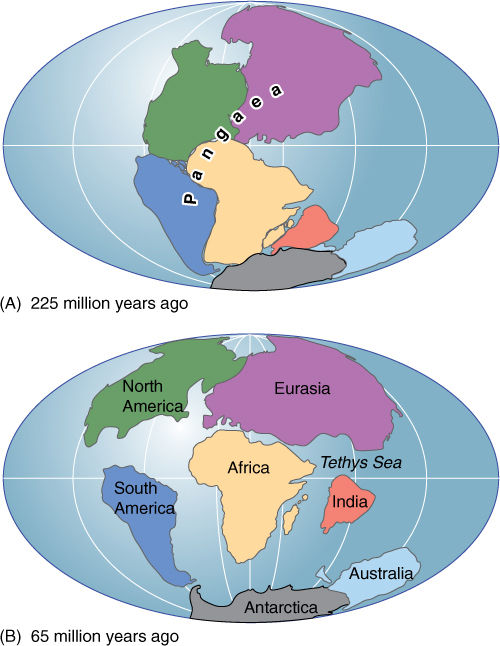
FIGURE 27-6 The continents have changed not only position, but size, shape, and profile as certain areas rise into mountain chains and other areas are covered by ocean when the sea level rises because of polar ice cap melting. Oceanic circulation changes as continents deflect or channel current movement, and this affects both transfer of moisture to the atmosphere and precipitation patterns.
Mesozoic Era
In the early Mesozoic Era (the Triassic Period), just after the Permian Period, the climate worldwide may have warmed. There is no evidence of glaciation anywhere, although polar regions did remain cool; away from the poles, the climate was warm and equable. Many new plant groups evolved at this time: Caytoniales, Cycadeoidophyta, Cycadophyta, and Ginkgophyta. Ferns increased in number, but many of the first major groups started to disappear. As the Triassic Period continued, the climate became more arid; the Triassic Period is the driest of all geological times. By the time of the Jurassic Period, Pangaea had many contrasting climates: The North American and Gondwanaland sections were arid, but the western Eurasia region was less so. Humid zones occurred in Australia and India, as well as in central and eastern Eurasia.
In the Jurassic Period, Pangaea began to break up; the North American segment moved northwestward. After separation from Eurasia occurred, the north Atlantic Ocean formed, producing a maritime influence on the two new coasts. Eurasia also began moving northward, separating from the southern portion of Pangaea. This resulted in the formation of a waterway, called the Tethys Sea, between the northern and southern continents. This area had alternated between marshy swampland and a shallow coastal sea; however, with continental separation, the Tethys Sea became deep, and oceanic circulation between southern and northern continents could occur on a large scale. The northward movement of the North American and Eurasian continents brought them out of the tropics and into the temperate zones, their northern regions extending into the north polar zones. Conifers evolved and spread throughout the regions that were becoming cooler and moister.
At approximately the same time, the Antarctic—Australian segment separated from the rest of Gondwanaland, and later Australia broke away and moved northward into the south temperate zone (FIGURE 27-6B). India separated from Africa and moved rapidly over a long distance. At the time of separation, India was located at the edge of the south temperate zone (about 30 degrees S latitude) and had a flora adapted to such a climate. It migrated rapidly, in just a few tens of millions of years, into the tropics, across the equator, and into the north temperate zone. The rapid fluctuation of climate in less than 70 million years was too much of a disturbance, and massive extinctions occurred. After it arrived at the Eurasian continent, the two collided, forming the Himalayan Mountains. As the two continents neared each other, plants could invade the foreign territory, some migrating northward onto the mainland, others spreading south from Eurasia onto India. This was to the detriment of India; its flora and fauna had not had time to become well adapted to the conditions of the north temperate zone, whereas the invaders from the mainland were well adapted.
In the Cretaceous Period, approximately 110 million years ago, South America separated from Africa, forming the southern Atlantic Ocean and allowing more humid oceanic air to reach west Africa. Until the breakup of Pangaea, Africa had the misfortune of being the dry center of the supercontinent. Its climate was so arid and severe that it had few species of plants or animals. With the formation of the Atlantic Ocean, Africa’s climate became much more humid and conducive to plant growth, but even today, the continent as a whole has many fewer indigenous species than one would expect if it had had a mild climate for a longer time.
Most continental pieces remained close together long enough for many newly evolved groups to migrate to most of the continents. The breakup of Pangaea occurred just as the flowering plants were becoming established, however, and as the North and South Atlantic Oceans widened, gene flow between the continents was reduced, and each developed unique floras. For example, the central deserts of Gondwanaland would have been ideal for cacti, but no cacti occur naturally in Africa, only in the Americas. The cactus family did not evolve until after the South Atlantic was wide enough to prevent the dispersal of cactus seeds from South America to Africa.
The latest major event in continental drift was (is) the collision of South America and North America. The two are coming together, and as always happens when continents collide, a mountain range forms. This collision started so recently, about 5 to 13 million years ago, that the mountains are short and are mostly still submerged below sea level. Only their tops protrude and are known as Central America and the Caribbean Islands. The formation of Central America created a continuous land bridge between the two continents, allowing plant species to be interchanged.
![]() The Current World Biomes
The Current World Biomes
As a result of continental drift, the United States is currently located almost exclusively in the north temperate zone and receives much of its weather from the Pacific and Arctic Oceans in winter and from the Pacific Ocean and tropical Atlantic Ocean in summer. Much of Alaska is situated in the polar zone, whereas Hawaii, Puerto Rico, and Guam lie in tropical waters.
Moist Temperate Biomes
Temperate Rain Forests
The northwest coast of the United States is formed by a series of mountain ranges that force westerly winds from the Pacific Ocean to rise as soon as they come ashore. Rain on the western side of the Olympic Mountains in Washington is often above 300 cm/yr. Rains are reliably present through autumn, winter, and spring, with only a brief period of summer dryness. Winters are mild, and only rarely is there frost; summers are warm but not hot. These conditions extend from northern California to Alaska, but they end at the summit of the Coastal Range, approximately 200 km from the coast.
Plant life in the temperate rain forest biome is dominated by giant long-lived conifers. Coastal redwoods of California are up to 100 m tall, and Douglas fir, western hemlock, and western red cedar form a canopy that reaches 60 to 70 meters. Forests can attain old age with little disturbance: Hurricanes and tornadoes do not occur, and fires are rare. The stability of the forest and the daily fog result in a rich growth of epiphytic mosses, liverworts, and ferns; the ground is covered with shrubs, herbs, and ferns (FIGURE 27-7). Temperate rain forests, containing totally different species, also occur in southwest Chile, which has the same climate.
Drier Montane and Subalpine Forests
As the westerly winds continue inland, they are drier and shed less rain on the Cascade Mountains and the Sierra Nevadas and then even less on the Rocky Mountains; each range feels the rain shadow effect of the preceding mountains. Montane forests occur at the bases of these mountains, subalpine forests at higher elevations (FIGURE 27-8). The first inland range in California is the Sierra Nevada; its lower elevations hold a montane forest of ponderosa pine, and some oaks from the valley floor may extend some distance up the slopes. At higher elevations is a mixed conifer forest, one containing many species of conifers: ponderosa pine, Douglas fir, white fir, incense cedar, and sugar pine. The most famous residents are the giant sequoia, the largest organisms in the world, much more massive than whales, being 80 m tall, up to 10 m in circumference, and weighing over 400 metric tons when dry. This species has been greatly harmed by lumbering and is currently found in only 75 groves. At the higher elevations are subalpine forests of lodgepole pine, whitebark pine, and mountain hemlock. These form open stands and give way to alpine meadows at their upper boundaries (FIGURE 27-9).
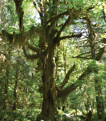
FIGURE 27-7 The Olympic National Park in Washington State encompasses a superb temperate rain forest, one of the moist temperate biomes. Abundant rain occurs almost every day. Temperatures are never extremely hot or cold, and disturbances are rare or nonexistent. The ecosystems in this biome are very stable. This bigleaf maple (Acer macrophyllum) is covered in a moss (Isothecium myosuroides).
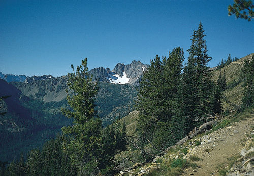
FIGURE 27-8 This is a drier montane forest (moist temperate biome), which may become warm in July and August and have several weeks without much precipitation. The forest is open and sunny and contains few epiphytes.
The Rocky Mountains are our most massive mountain range, extending in a broad band from Alaska south through Canada, Idaho, Montana, Wyoming, Utah, Colorado, Arizona, New Mexico, and Mexico. Being the third range from the coast, it is the driest, receiving as little as 40 cm of rain per year; the southern Rockies are especially dry and warm. The subalpine forest contains Engelmann spruce over the entire length of the range, but in the north, other trees are alpine larch and whitebark pine; in the south, varieties of bristlecone pine are part of the subalpine forest. The montane forests typically contain Douglas fir in their higher elevations, ponderosa pine in lower ones. The montane forests on the Rocky Mountains are frequently subjected to fire, as often as every 5 years under natural conditions. Ponderosa pine is well adapted to fire and survives it easily. Other plants are killed, and fires create open grassy areas around the pines.
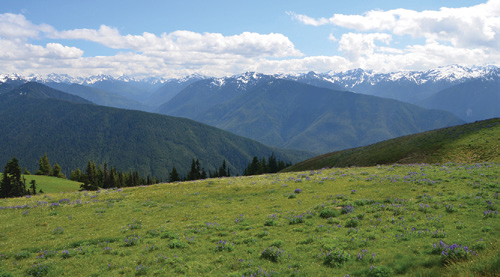
FIGURE 27-9 High elevations have increased precipitation and winds and decreased temperature and growing season. The montane forest gives way to alpine meadows. Many areas are flat enough that small bogs and marshes form, being rich in sedges.
In drier montane and subalpine forests, soil is shallow, rocky, and very well drained; it tends to be acidic. Water stress in summer is not uncommon, due both to sparse rain and to rapid runoff through porous soils on steep slopes (FIGURE 27-10). Much of the available moisture comes as the melting of winter snow.
In the eastern United States, the Adirondacks and Appalachians are tall enough to support montane and subalpine forests. In the Adirondacks, a spruce/fir subalpine forest extends down to 760 m and contains balsam fir (FIGURE 27-11). In the warmer southern climate, the lower limit for subalpine forest is higher: 990 m in the Appalachians and 1,400 m in the Smoky Mountains. Above these elevations are stands of red and black spruce and Fraser’s fir. Below the subalpine conifer forests are montane forests composed of hardwood, not conifers; these are described in the next section.
Temperate Deciduous Forests
The climate that produces the temperate deciduous forest biome is one with cold winters and warm but not hot summers and relatively high precipitation in all seasons. Whereas the drier montane and subalpine forests of the Rocky Mountains have streams with running water restricted mostly to springtime when snowpack is melting, the northeastern temperate deciduous forest has streams that flow year round. Much of the precipitation in the northeastern region is derived from summer weather systems that move northward out of the central Atlantic Ocean or from winter storms that blow southward from Arctic seas.
FIGURE 27-10 Much of the dryness of the Rocky Mountains is due to edaphic (soil) conditions as well as to climate. Because these mountains are still very young and steep, soil formation is slow and erosion is rapid. Thin, rocky soil is not effective at holding any moisture that does fall, and in summer, plants often have little soil moisture available.
The temperate deciduous forest in the United States occupies lower, warmer regions, whereas higher, cooler elevations support the subalpine vegetation of the Appalachians and Adirondacks (FIGURE 27-12). Dominant trees vary geographically, but tall, broadleaf deciduous trees such as maple and oak are frequent everywhere, maples being more common in the north and oak in the south. Intermixed and forming a subcanopy are dogwood, hop hornbeam, and blue beech. The shrub layer is sparse because of heavy shade provided by broadleaf dominants, but witch hazel, spicebush, and gooseberry are common. The ground layer is covered with r-selected herbs that thrive during spring just before trees leaf out. Such a spring sunny period does not occur in evergreen forests.
The foliage of these angiosperm trees contains fewer defensive chemicals than do the needles and scale leaves of a conifer. There may be 3 to 4 metric tons of broadleaf foliage per hectare in a temperate deciduous forest, and as much as 5% is consumed by herbivores; the rest is abscised in autumn and decays quickly in the humid conditions produced by frequent rain. A thick layer of litter does not accumulate.
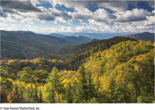
FIGURE 27-11 The Appalachian Mountains are ancient and have been eroded extensively so that they are low and gently sloped and have a thick, rich soil. The higher elevations support subalpine forests of conifers, and the lower elevations have montane forests of hardwoods (dicots).
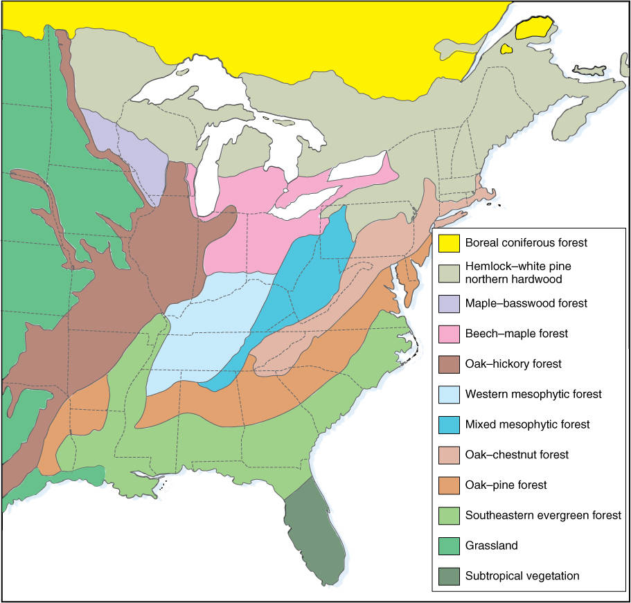
FIGURE 27-12 The temperate deciduous forest (moist temperate biome) is an extensive and complex biome in the eastern United States consisting of many subdivisions. This is an area of low, nonmountainous topography with cold, wet winters and warm, rainy summers. Soils are deep.
The forest is not uniform across its entire breadth. The geographic extent of temperate deciduous forest biome contains numerous soil types, various altitudes, and gradients of temperature and precipitation. As many as nine subdivisions have been recognized, such as oak/hickory forest (Illinois, Missouri, Arkansas), oak/chestnut forest (Pennsylvania, the Virginias), oak/pine forest (east Texas, northwest Louisiana, and northern parts of Mississippi, Alabama, Georgia, and the Carolinas), beech/maple forest (Michigan, Indiana, Ohio), maple/basswood forest (Wisconsin, Minnesota), and hemlock/white pine forest (northern Wisconsin to New York).
Forests in these areas have a rich species diversity, and their considerable vertical structure provides a diversity of habitats for animals and fungi. Much animal life is located above or below ground, not at its surface. Most birds make their nests on branches or in holes in the trunk. Small mammals may burrow, but many are arboreal. As in the coniferous forest at higher elevations here and in the inland western mountains, strong climatic differences exist between summer and winter, accented by the deciduous nature of the broadleaf forest. Autumn leaf fall ends the feeding period for aerial insect leaf eaters but initiates the season for decomposers and insect herbivores of the litter zone. Many birds migrate to wintering grounds, but other species may migrate from farther north. Disturbance is not common; fires are rare and hurricanes that enter the regions usually lose destructive power quickly and change into widespread weaker storms (FIGURE 27-13).
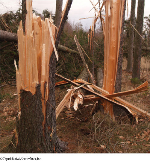
FIGURE 27-13 Hurricanes move westward in the Atlantic but turn north-northeastward as they approach land. Many enter land between Texas and Florida and then move up the Mississippi River Valley or just east of it. The winds lose their hurricane force immediately and change into a giant storm system that supplies summer rainfall.
Southeastern Evergreen Forests
This biome shows the powerful effect that disturbance and soil type exert. The southeastern evergreen forest biome occurs at the southern edge of the oak/pine component of the temperate deciduous forest, along the northern portions of the Gulf States, the top of Florida, and the coast of the Carolinas. Its climate is similar to that of the inland region except that winters are warmer; frosts occur but the ground does not freeze. Precipitation is higher than in inland temperate deciduous forest areas, but the soil is so sandy and porous that rainwater percolates downward rapidly and runs off into streams. Shortly after a rain, the soil is dry. The region has a definite dry aspect to it.
In addition to rapid drainage, the biome is shaped by frequent fires; lightning initiates fires that burn rapidly through the litter of fallen pine needles that decompose only slowly (FIGURE 27-14). As a result of fire disturbance and soil conditions, the forest consists almost purely of fire-adapted longleaf pine with occasional oaks. The fact that fire rather than climate is the primary biome determinant has been proven by fire prevention: Repeatedly suppressing fire lets broadleaf seedlings survive and quickly changes the forest from pines to oaks, hickories, beeches, and evergreen magnolias.
Dry Temperate Biomes
Grasslands
The entire central plains of North America, extending from the Texas coast to and beyond the Canadian border is—or more accurately, was—grassland, often referred to as prairie (see Figure 27-2). This part of North America has no mountains, being too far from the various continental collision zones; it is remarkably flat, with at most low, rolling hills. It is characterized climatically as drier than the forests discussed so far, being located in rain shadows of the prevailing westerlies but out of reach of many Atlantic weather systems. Rain is only about 85 cm/yr. Seasons vary from bitterly cold winters, especially in the north, to very hot summers. Climate and vegetation factors have produced some of the richest soil in existence anywhere. Rainfall is sufficient to promote reasonably rapid weathering of rock, but it is not so great as to leach away valuable elements. Grasses produce abundant foliage that, rather than abscising and falling to the soil, is eaten by herbivores, often large mammals such as cattle or, in the past, buffalo. Vegetable matter is returned to the soil as manure that decomposes rapidly, enriching the soil and increasing its water-holding capacity. Because of the lack of trees, except along rivers, no treetop habitats are available for animals such as squirrels. All small mammals burrow, and birds nest on the ground.
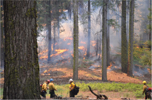
FIGURE 27-14 Not all fires are the raging infernos you see on TV news. Low, cool fires burn frequently through southeastern evergreen forests, one of the moist temperate biomes. This kills nonadapted species but leaves pines and cabbage palms: Without fires, seedlings of broadleaf trees would soon overtop the pines and make the forest floor too shaded for pine seedlings. This is a controlled burn in Sequoia National Park.
Botany and Beyond
BOX 27-1 Measuring Ancient Continental Positions and Climates
Continents move across Earth’s surface, propelled by circulation patterns in the mantle. It is possible to discover where the continents have been located in the past by employing several techniques; the most important is studying paleomagnetism. Many rocks contain magnetic minerals, and when these rocks are fluid, as in lava or magma, the minerals become aligned with Earth’s magnetic field. After rock solidifies, its magnetic alignment is fixed. If the magnetic orientation of a rock does not point to the north magnetic pole, we know that there has been a shift in the rock’s position since it was formed. Studying the magnetic orientation of extensive blocks of rock of known age reveals the position of the rock at the time of formation.
Another technique important for identifying past positions of continents is the analysis of their past climates. Signs of ancient glaciation (characteristic scouring marks) indicate that the continent must have been near a polar region or at high altitude. The mineral bauxite forms only under moist, warm conditions; therefore, its presence is an excellent indicator of tropical location in the past. Mineral deposits called evaporites are formed by evaporation of water from small, shallow seas located on a continent near a coast, like the Dead Sea today. They indicate that temperatures were high and precipitation low. Carbonic acid in seawater reacts with calcium to form carbonate, a temperature-dependent process; carbonates are found only in warm tropical waters. The presence of fossilized coral also indicates warm, shallow seas, whereas coal fields are derived from the fossilization of plants that lived in warm, rainy conditions.
In many areas, the history of each square mile is known for a period of millions of years, and the drifting has been mapped in great detail. This allows us to consider how continental drift has affected the origin of life on land and the evolution of ecosystems and biomes.
Because the soil is so rich, almost all of the grasslands have been converted to farms; virtually nothing remains of the original biome. Efforts are being made to re-establish grassland prairie by removing all domesticated plants and seeding in grasses and other species known to have occurred originally, such as composites, mints, and legumes (FIGURE 27-15). It is still too early to tell how successful these reconstruction efforts will be, but many fear that the plots are too small (a few hectares) and should instead be extensive enough to support herds of buffalo if the full ecosystem is to be restored.
It is not known for certain what the critical factors were that caused this region to be grassland as opposed to forest. The buffalo may have been important; they roamed in unimaginable numbers, and tree seedlings would have been poorly adapted to survive their grazing (FIGURE 27-16). Also, Indians set prairies afire periodically, which caused grasses to grow especially luxuriantly the following year, providing better feed for buffalo; seedlings of tree species were killed by the fire. A recent hypothesis is that grasses support a type of mycorrhizal fungus that outcompetes and eliminates the type of fungus necessary for forest trees.
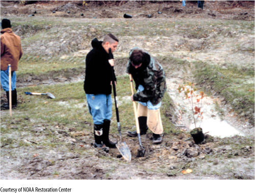
FIGURE 27-15 Many groups are undertaking efforts to re-establish natural prairies. Native grasses are planted and nonnative species weeded out. The animal communities must be re-established also to truly recreate the biome and make it self-perpetuating. Extensive acreage would be required to supply enough primary consumers to support the secondary consumers.
Extensive grasslands occur between the Cascade Mountains and Rocky Mountains, the result of the Cascade’s rain shadow. These extend from northern Washington south through Oregon and Nevada. Much of them remain, but they are grazed; large parts have been cleared and used for irrigated farms.
Shrublands and Woodlands
A woodland is similar to a forest except that trees are widely spaced and do not form a closed canopy. If grass grows between the trees, the biome is known as a savanna instead (FIGURE 27-17). Shrublands are similar except that trees are replaced by shrubs. Woodlands and shrublands often occur as the transition between a moist forest and a dry grassland or between grassland and desert. Soils often have a high clay content.
The chaparral in California is a well-known shrubland (FIGURE 27-18A). Its climate consists of a rainy, mild winter followed by a dry, hot summer; drought occurs every year. Much of the California chaparral is dominated by short shrubs, 1 to 3 m tall, but at higher elevations, manzanita, buckthorn, and scrub oak occur. Many plants have dimorphic root systems: Some roots spread extensively just below the soil surface, but a tap root system reaches great depths. The two together allow plants to gather water from the deep, constant water table and from brief rains that penetrate only a few centimeters into the soil.
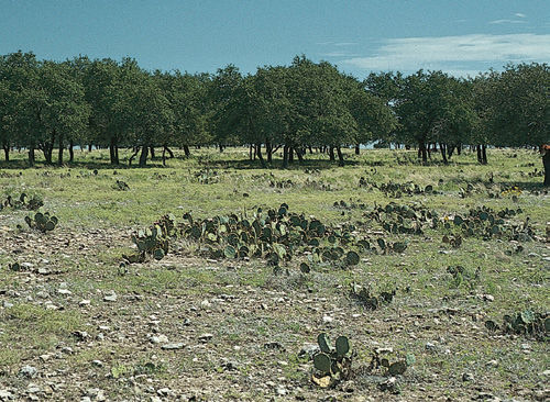
FIGURE 27-16 Large mammalian herbivores such as buffalo, deer, moose, and elk are important factors in their ecosystems. Grasses have basal meristems on their leaves and the shoot apical meristems are low, and thus, grasses can be grazed without being killed. Grazing of shrubs and tree saplings destroys the leaves and the shoot apical meristems; therefore, grazing tends to maintain a prairie as a grassland, free of trees. If too many cattle are fenced into an area, however, they overgraze it, killing even the grasses by eating leaves so quickly that no photosynthesis can occur. In this overgrazed pasture, the oaks and cacti have a selective advantage because their tough, bitter leaves or spines deter grazing.
Fires occur frequently in California chaparral and are always in the news because of the houses they destroy. Low rainfall allows dry litter to accumulate without decomposing, and dead shrubs persist upright as dry sticks (FIGURE 27-18B). An area typically burns every 30 to 40 years, with fires most frequent in summer. Winter rains cause flooding, erosion, and mudslides after a fire because no vegetation remains to hold soil in place. Although the shrubs and trees are fire adapted and resprout quickly, the main new growth is by annual and perennial herbs. These are present before the fire as seeds, bulbs, rhizomes, or other protected structures, and after the burn, they grow vigorously, free of shading by charred shrubs; a release of minerals from the ash also enriches the soil (FIGURE 27-18C). A few years after fire, larger shrubs dominate the biome again, and herbs are suppressed, perhaps by allelopathy, perhaps by recovery of the herbivore population.
Farther east, drier climates and higher elevations result in pinyon/juniper woodland instead of chaparral shrubland. Rainfall is only 25 to 50 cm, and soils are rocky, shallow, and infertile. The vegetation is a savanna of pinyon pine—small, slow-growing trees with short needles—and juniper trees that may have the stature of large shrubs (FIGURE 27-19). In Arizona and New Mexico, oaks may be important. Trees are widely spaced, and between them is a grassy vegetation; the species are bunch grasses that grow in clumps, not the mat-forming species of the central plains. Between the bunch grasses is bare soil. Sagebrush and bitterbush occur in the northern parts of the biome.
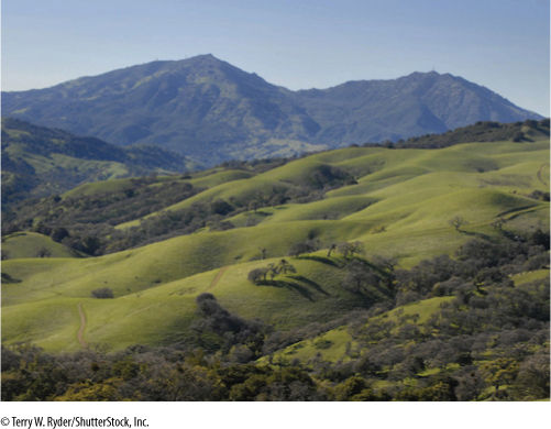
FIGURE 27-17 If trees are widely spaced and grass grows between them, it is a woodland biome, a type of dry temperate biome. This is a transition biome, representing the interface between a forest and a grassland, but it is not just the mixing of the two. Many birds nest in the trees but feed in the grasslands; they cannot live in pure forest or pure grassland.
Desert
The driest regions of temperate areas are occupied by deserts, where rainfall is less than 25 cm/yr. Deserts are either cold or hot, based on their winter temperatures (FIGURES 27-20 and 27-21). A hot desert has warm winter temperatures. In the United States, this climate occurs in rocky, mountainous areas of southern California, Arizona, New Mexico, and west Texas, but in other parts of the world, it may occur on flat, sandy plains, as in the Sahara. Three separate and highly distinct deserts actually occur in the southwestern United States and northern Mexico: the Chihuahuan Desert in west Texas, New Mexico and Mexico; the Sonoran Desert in Arizona and northwestern Mexico; and the Mohave Desert in southeastern California, southern Nevada, and northwestern Arizona.
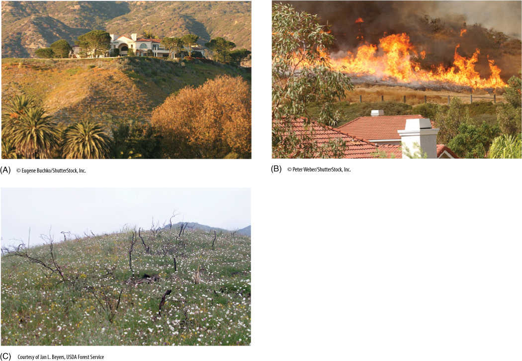
FIGURE 27-18 (A) This is California chaparral, one of the most famous shrubland biomes; such shrubland extends from California across the southwestern United States and northern Mexico into west Texas. Fire is an important disturbance that maintains this biome; it is being invaded by the large mammal Homo sapiens, which is protected by fire insurance policies and government disaster aid policies. (B) The resinous leaves and accumulated dry litter cause frequent fires to be inevitable. (C) Seedlings of r-selected species flourish in the spaces opened by the burning of the dominant shrubs. These spots remain open only temporarily because the shrubs are fire adapted and recover after a few years.
Desert soils are rocky and thin; what little soil occurs may blow away, leaving nothing but pebbles. Brief, intense thundershowers wash soil out of mountains and deposit it in large alluvial fans at valley entrances; fans often have the deepest soil and their own distinct vegetation. The most abundant plants in our hot deserts are creosote bush, bur sage, agaves, and prickly pear. Most perennial plants have one or several defenses against herbivores—chemicals and spines being the most common. Joshua tree, an arborescent lily, grows in the Mohave desert, and numerous other needle-leaf yuccas and agaves are abundant; cacti are ubiquitous. Deserts are highly patchy ecosystems, and slight variations in soil type, drainage, elevation, or covering vegetation can cause abrupt changes in vegetation. In valleys or mountains, slopes that face the equator intercept light almost perpendicularly and so are much warmer and drier than those that face away from the equator and are lighted obliquely. The hotter side has the richer xerophyte vegetation.
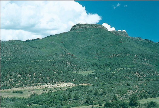
FIGURE 27-19 East from the California chaparral is the drier pinyon/juniper woodland, shown here in southern Colorado and northern New Mexico. Soils are rocky, thin, and poor, and in many areas, chaparral grades into a desert or desert—grassland.
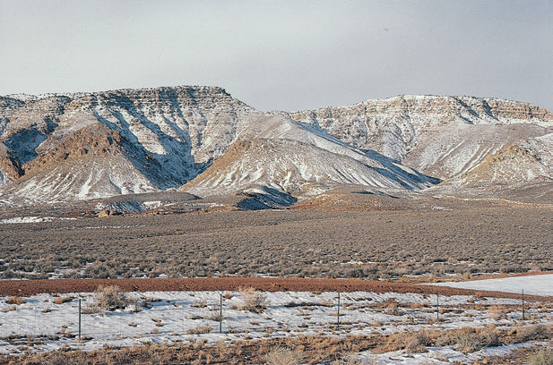
FIGURE 27-20 The Great Basin Desert is a cold desert (in the winter only); it extends from near Las Vegas in the south well into Washington, encompassing much of Nevada, eastern Oregon, and western Idaho. It has two dominant plants, sagebrush (Artemesia tridentata) and a bunch grass (Bromus tectorum). Even the northern parts have cacti (Pediocactus and prickly pear), although they tend to be inconspicuous.
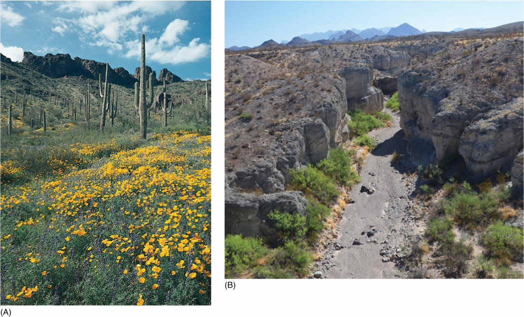
FIGURE 27-21 (A) For most North Americans, “desert” means Arizona and saguaro cactus (Carnegiea). (B) Streams of the western deserts have water only after a thunderstorm. At that time, the water flows as a flash flood, moving at tremendous speed and carrying not just silt but entire boulders. Their banks contain trees such as cottonwood, palo verde, or mesquite whose deep roots tap moisture that remains in the streambed after the surface water has run off.
Alpine Tundra
The biome located above the highest point at which trees survive on a mountain, the timberline, is alpine tundra (FIGURE 27-22). In the equatorial region, elevations as high as 4,500 m can support tree growth, but in the cooler regions at 40 degrees N (approximately the middle of the United States), elevations as low as 3,500 m are too severe for trees. Alpine tundra is cold much of the year, with a short growing season limited by a late snow melt in spring and early snowfall in autumn. Soils are thin and have undergone little chemical weathering. Summer days can be surprisingly warm and clear, and many plants flourish in the brief summer. Nights are generally cold in all seasons, and severe, violent weather can occur at any time. The dominant forms of plant life are grasses, sedges, and herbs such as saxifrages, buttercups, and composites. Dwarf plants growing with densely packed stems and leaves are common and are known as cushion plants. Much of the alpine tundra land occurs as flat meadows with shallow alpine marshes.
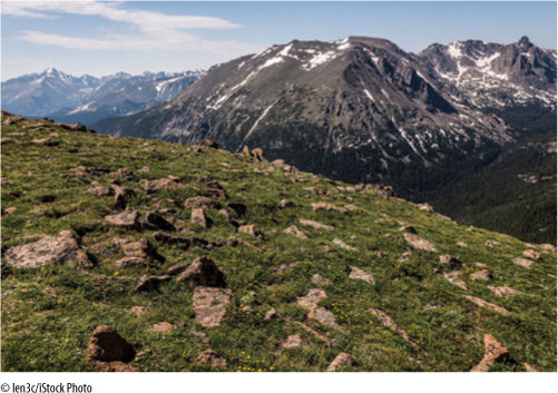
FIGURE 27-22 Plants in the alpine tundra biome face short, cold growing seasons, and often, snow is never gone from the shaded areas below cliffs. Soils are thin and ultraviolet light is intense.
It is not known for certain why trees do not grow above the tree line. Those near the highest elevation are short and typically have branches mostly on the side away from the wind; at a slightly higher elevation, trees are extremely misshapen and gnarled, known by the German word krummholz; the forest is called an elfin forest. It is believed that blowing snow and ice abrade the trees’ surfaces, permitting desiccation and death.
In North America, most alpine tundra biomes occur on the tall mountains in the west, but Mt. Washington in New Hampshire and Whiteface Mountain in New York are high enough to have regions of alpine tundra.
Polar Biomes
Arctic Tundra
Polar regions contain few significantly dry areas (FIGURE 27-23). Precipitation, usually snow, may be low, but evaporation is also low—therefore, moisture persists. In the extreme northern latitudes, the ground freezes to great depths during winter, and summer is too cool to melt anything more than the top few centimeters. Below this, soil is permanently frozen and is known as permafrost.
Like alpine tundra, arctic tundra has a short growing season of 3 months or less, and temperatures are cool, averaging only about 10°C. Freezing temperatures can occur on any day of the year. Arctic soils have a high clay content and are poor in nitrogen because nitrogen-fixing microbes are sparse. Permafrost prevents drainage when the soil surface melts in summer, and thus, soils are waterlogged and marshy. Bogs, ponds, and shallow lakes are common.
Arctic tundra vegetation contains even more grasses and sedges than does alpine tundra, as well as many more mosses and lichens. Almost nothing is taller than 20 cm, even the dwarf willows and birches that occur. Many plants have underground storage tubers, bulbs, or succulent roots; more than 80% of a plant’s biomass may be underground even during summer.
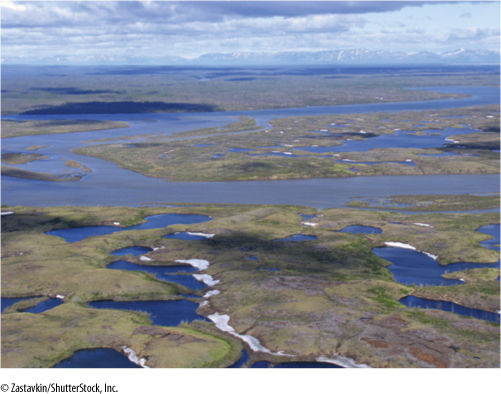
FIGURE 27-23 Arctic tundra, one of the polar biomes, is marshy and wet when not frozen solid; permafrost prevents water from seeping into the soil, and the area is so flat that runoff is slow. This area was on the trailing edge during the formation of Pangaea and has not collided with any other tectonic plate; therefore, it has not undergone mountain building. Antarctic tundra is located on the Andes Mountains where drainage is excellent.
Boreal Coniferous Forests
Just south of arctic tundra is a broad band of forest, the boreal coniferous forest (FIGURE 27-24). Boreal means northern, just as austral means southern (Australia). This forest occurs completely across Alaska and Canada and throughout northern Eurasia in Scandinavia and Russia. The Russian name for this biome is taiga, a term frequently used in the West. The boreal forest is an ancient biome, and its formation was strongly influenced by the diversification of division Coniferophyta just as the North American and Eurasian plates were breaking away from Pangaea and their northern parts were leaving the tropical zone and entering the north temperate, subarctic zone.
Boreal forest is almost exclusively coniferous; conifers appear to be adapted to this climate because they are evergreen and capable of photosynthesizing immediately whenever a sunny day occurs. Deciduous angiosperms would be limited to the short growing season, less than 4 months long. Conifers have drooping branches that shed snow easily; without this architecture, snow loads can easily break off limbs. Although the Coniferophyta contains many species, the boreal forest is not rich in diversity; it is not unusual for only two species to dominate thousands of square miles completely. Black spruce and white cedar may dominate western areas, whereas white spruce and balsam fir cover much of the eastern area. Shrubs are not abundant but include blueberries, blackberries, and gooseberries. Herbs are also sparse. Not much disturbance occurs in the boreal forest; fire may occur in the south and insect plagues in northern parts. This biome does contain many large mammals such as moose, caribou, deer, grizzly bear, and timber wolves. Boreal forest is continuous with and grades into subalpine and montane forests that occur farther south. Many species may occur in both biomes.
Tropical Biomes
Most tropical biomes are characterized by a lack of freezing temperatures. On high mountains in the tropics, cool or cold nights and winters occur, but only at very high elevations is frost encountered. Under conditions of high rainfall, tropical rain forests develop, but the drier areas contain tropical grasslands and savannas.
Tropical Rainforests
Tropical rain forests occur close to the equator; Hawaii, Puerto Rico, and Guam have extensive rain forests (FIGURE 27-25). Precipitation is high, typically over 200 cm/yr and often as much as 1,000 cm/yr (10 m—over 30 feet—of rain). Rains typically occur every day. The morning may be cool and fresh, but clouds develop rapidly, and rain almost invariably falls by noon. After a rain, there are large clouds in a clear sky and bright sunlight; the temperature quickly rises, and the relative humidity of the air is close to 100%.
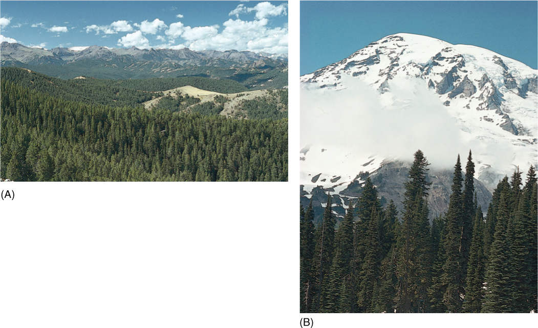
FIGURE 27-24 (A) Within any square kilometer of boreal forest there may be thousands of individuals of the same species; therefore, the wind pollination of conifers is highly efficient. (B) Conifers dominate the boreal forest; flowering plants tend to be understory shrubs and herbs.
High temperatures and moisture cause much more rapid soil transformation here than in other biomes. Many elements are leached from the soil, leaving behind just a matrix of aluminum and iron oxides. Humus decays rapidly, and there is little development of soil horizons. An extensive system of roots and mycorrhizae catch and recycle minerals as litter decays. Almost all available essential elements exist in the organisms, not in the soil.
The dominant trees are angiosperms; virtually no conifers occur naturally in tropical rain forests. The canopy is 30 to 40 m above ground level, but numerous large trees emerge above all others. A subcanopy may occur at about 10 to 25 m. Some trees have massive, gigantic trunks, but most are slender. In an undisturbed area where the canopy has remained intact for years, ground vegetation is minimal, and it is easy to walk through the forest. Localized disturbances happen when a large tree dies and falls, creating a gap in the canopy. Suddenly, light is available on the forest floor, and herbs and shrubs proliferate; however, a tree soon grows up and fills the canopy, blocking light.
Virtually all small shrubs and herbs occur as epiphytes, located high in the canopy, nearer the light. Orchids, bromeliads, aroids, and cacti are common. Numerous vines are anchored in the soil, but their stems grow to the canopy and then branch and leaf out profusely. Leaves and roots can be separated by a narrow stem 50 m long.
The tropical rain forest is synonymous with species diversity. A single hectare (a square 100 m on each side) may have over 40 species of trees, often up to 100, and a single tree may harbor thousands of species of insects, fungi, and epiphytic plants. With such diversity, each hectare may have only one or two individuals of a particular species, especially of trees. No dominants occur. With such low population density for most species, wind pollination is not successful. All plants must be pollinated by animals, and being noticed by a pollinator can be difficult; many subcanopy species have brilliantly colored flowers that are easy to see in the dim light, and scents tend to be so strong that insects and birds find the flowers quickly. Large trees can undergo a massive flowering that no pollinator could possibly ignore (FIGURE 27-26).
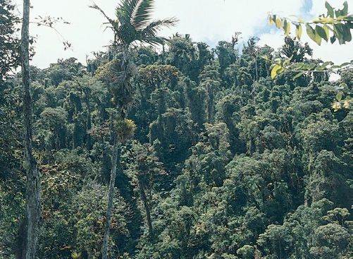
FIGURE 27-25 Unlike temperate rain forests, tropical rain forests (one of the tropical biomes) are never exposed to freezing conditions. Photosynthesis can occur throughout the year. Because leaves are not deciduous, their useful lifetime is not limited to just several summer months, but rather they can be effective for several years (Panama).
Tropical Grasslands and Savanna
Those areas of the tropics with lower rainfall develop as thorn-scrub (low, spiny trees and shrubs; FIGURE 27-27), savannahs or grasslands (no trees; FIGURE 27-28). The best known savannas are in Africa, but they also occur in Brazil (the cerrados), Venezuela (the llanos), and Australia. Under natural conditions, undisturbed by humans, the vegetation consists mostly of bunch grasses up to 1.5 to 2 m tall. Most of the trees are open, flat-topped, widely scattered legumes. The South American savannas do not have many large grazers, but those of Africa are famous—zebras, wildebeests, and giraffes. An unexpected but very important grazer is the termite; termites are abundant and build giant nests of soil particles and plant debris. They bring in large amounts of plant material, digest it, and add their fecal material to the termite mound. Colonies are so abundant and the mounds so large that termites are a major link in nutrient cycling.
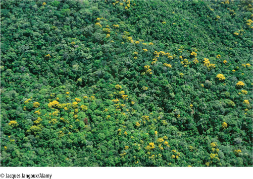
FIGURE 27-26 In tropical rain forests, many trees undergo massive flowering, involving not only simultaneous opening of all flowers on one tree but also the flowering of all trees of a particular species within an area. In some plants, this is triggered by changes in air temperature or humidity associated with a rainstorm at the end of the dry season.
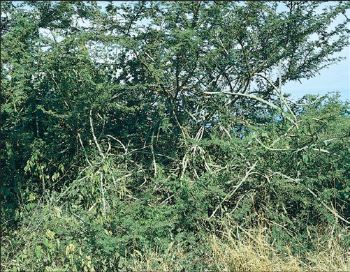
FIGURE 27-27 Along coastlines in tropical areas, the low-lying, flat terrain receives relatively little rainfall, and the sandy soil allows what little rain there is to seep away quickly. Conditions are desert like, except for very high humidity. There may be a coastal thorn-scrub biome, so named because the trees are short and most bear spines. Even the vine here is a cactus (Acanthocereus).
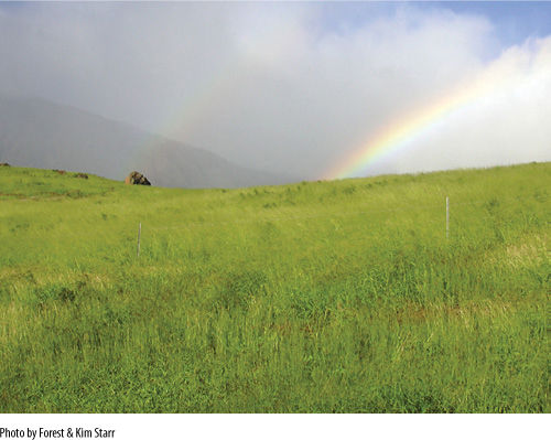
FIGURE 27-28 Tropical grassland is a tropical biome in which rainfall is not abundant enough to support forest. There is no cold winter, but rather three seasons: warm and wet, cool and dry, hot and dry.
 At the Next Level
1. Your own biome. Biomes are strongly affected by mountains, oceans, wind patterns, latitude, and other factors. A good way to understand these factors and how they interact is by investigating your own biome, the area near your own home. Do you live in the lowlands or in the mountains? If mountains, what is their height and age? (Which are taller, the Rocky Mountains or the Appalachians? Which are older?) Where do the winds and moisture originate that affect you, and does this pattern change with season? What is your latitude? Do you live in an area that was covered by an ice sheet until a few thousand years ago?
2. Fire-adapted biomes. Several of the dry temperate biomes are adapted to frequent disturbance by fire. The chaparral in California is perhaps the most famous because several cities and thousands of people live in the chaparral and homes burn every year. This chapter introduced several aspects about fire ecology in the chaparral, but you should search for more information about the timing of rainy periods and dry periods with regard to the timing of flowering and seed production. Also, the animals of the chaparral must also survive fires; what are their adaptations?
3. Biomes and global warming. The greenhouse gases we are releasing into the atmosphere are causing Earth’s temperature to increase. But rather than having every area on Earth become slightly warmer, the extra heat will alter the circulation of the oceans and thereby alter heat distribution from the tropics to the polar regions. Some areas will become much warmer, but others cooler; some will have more rain, others will have less. So many factors affect circulation in the oceans that we are not yet confident what will happen, but many models have been published. Search for information about predictions for ocean circulation, and give attention not only to what the outcomes might be but also what the factors are that cause changes (such as increased freshwater from melting ice and altered sinking of water as it becomes cold and dense near the poles). In addition, be certain to examine maps of the ocean basins—many aspects of circulation are controlled by the topography of the basins, with water moving easily where the ocean floor is smooth, less easily where there are mountain ranges on the ocean floor.
SUMMARY
1. Biomes are groupings of ecosystems; although controlled by diverse factors such as climate and soil, many biomes are distinctive enough to be easily recognizable.
2. Earth’s climatic patterns result from several factors, including tilt of the axis of rotation, circulation of the atmosphere and oceans, and positions, shapes, and sizes of the land masses.
3. The warmest and most humid zone worldwide is located between the Tropics of Cancer and Capricorn. Temperate zones are farther from the equator and are cooler and drier; polar regions are cold.
4. The climate of a particular land mass is determined by its latitude, its size, the warmth of adjacent ocean currents, humidity and temperature of winds, and rain shadows produced by mountains.
5. The nature of many types of mineral deposits is affected by climatic conditions of heat and humidity; the minerals act as a record of past climatic conditions. Certain fossil life forms (coal and coral) are also good indicators. Paleomagnetism shows the past orientation and position of the continents.
6. In the late Paleozoic Era, just as land plants were appearing, all continents came together, forming Pangaea; during the Jurassic Period, Pangaea fragmented into the present continents. As each drifted, many moved into new latitudes, and their climates changed dramatically, affecting their life forms. Altered ocean circulation permitted moist air to cover more of the land surface.
7. Moist temperate biomes have high rainfall, and winters are cool or cold. Several biomes are temperate rain forest, montane and subalpine forest, temperate deciduous forest, and southeastern evergreen forest.
8. Dry temperate biomes have cold winters and moderate rainfall: grasslands, shrublands, woodlands, desert, and alpine tundra.
9. Polar biomes have low light intensity, long summer days, long winter nights, and permafrost. In arctic tundra, much of the biomass is located below ground as bulbs and tubers. Boreal forest (taiga) is an extensive circumpolar forest dominated by conifers.
10. Tropical biomes are influenced strongly by the complete absence of freezing temperatures; where rainfall is high, tropical rain forest develops. If rain is less abundant, tropical grasslands exist.
IMPORTANT TERMS
alpine tundra
arctic tundra
biomes
boreal coniferous forest
chaparral
continental drift
deserts
evergreen forest
Gondwanaland
grassland
Laurasia
montane forests
Pangaea
permafrost
rain shadow
savanna
shrublands
taiga
temperate deciduous forest
temperate rain forest
Tethys Sea
tropical rain forests
tundra
woodland
REVIEW QUESTIONS
1. Earth’s land surface is covered by biomes, extensive groupings of many ________________. Are these characterized by distinctive aspects of both plants and animals or by just one of the two?
2. Biomes vary from extremely simple to more complex. Name a simple biome. Name two complex ones. Biome complexity is most strongly influenced by two abiotic factors: ____________________ and ____________________.
3. Why are the Florida Keys desert islands? Why are the Hawaiian Islands and Puerto Rico not desert islands?
4. Why does the west coast of the United States and Canada receive so much more rain than the central plains? What is the source of rain that prevents the central plains from being a complete desert—the Pacific Ocean, the Atlantic Ocean, the Gulf of Mexico?
5. What is the latitude where you live? Which coast is closer to your location? Does it influence your climate significantly?
6. What is the precipitation pattern in your area—mostly in summer or winter? What is typically the longest time between rains—10 days, a month? Does this dry period occur in summer or winter?
7. Are the soils in your area thin, rocky, and immature or thick and rich?
8. In the late Paleozoic Era, at about the time life was beginning to move onto land, all of the continents drifted together. What is the name we use for that supercontinent? What is the name for the northern part of it? What is the name for the southern part? Later, the continent broke up, and as the northern part separated from the southern part, a waterway was formed. It is called the ___________________ Sea (it no longer exists). When North America drifted to the northwest and broke away from Europe, another waterway was formed. It is called the ______________________ Ocean (this still exists).
9. The northwestern United States is a temperate rain forest biome, and the western side of the Olympic Mountains often receives more than ___________________ cm of rain per year. There are 2.5 cm in every inch. How many inches of rain is this?
10. The northeastern United States is dominated by temperate deciduous forests. What does “temperate” mean? What is a “deciduous forest”? Describe the climate that produces the temperate deciduous forest. What are its winters, summers, and rainfall like?
11. The entire central plains of North America is—or more accurately, was—grassland, often referred to as prairie. Why does the sentence say “was”? What has happened to the grassland of the central plains? What is the soil like—thick and rich, or thin and poor?
12. Chaparral in California is a famous shrubland. What is a frequent disturbance in chaparral, one that is in the news every year? How are native chaparral plants adapted to this disturbance?
13. What is your image of a desert—dry and lifeless? Look at Figure 27-21 of a desert in Arizona. Do you think this area looks like this all year long?
14. What is the boreal coniferous forest? Where is it located? The boreal forest is almost exclusively coniferous, whereas just to the south are the temperate deciduous forests. Why is the more northern region dominated by conifers?
15. There is no huge, extensive austral coniferous forest. Why not (Hint: Look at Figure 27-3; is there any land at the corresponding latitude in the Southern Hemisphere)?
16. Of the biomes discussed in this chapter, in which do you live? What are the dominant plants in your biome? What are the dominant animals other than humans? What are the most significant causes of ecological alteration in your area—urban development, logging, agriculture? What have been some of the changes caused by this?
17. Name all of the state and national parks or wilderness areas located within one day’s drive of your home. How many of these have you visited? Of all the biomes mentioned in this chapter, how many have you traveled through? Did you notice the changes in vegetation?
Design Credits: Hummingbird: © Tongho58/Moment/Getty; Green plant cells: © ShutterStock, Inc./Nataliya Hora; Purple tulip: © ShutterStock, Inc./Marie C Fields; Dandelion: © ShutterStock, Inc./danielkreissl; Poppy: © ShutterStock, Inc./Saruri; Plant icon: © ShutterStock, Inc./Vector; Digging man icon: © ShutterStock, Inc./Z-art