THE LIVING WORLD
Unit Eight. The Living Environment
36.8. Patterns of Circulation in the Ocean
Patterns of oceanic circulation are determined by the patterns of atmospheric circulation, which means that indirectly, the currents are driven by solar energy. The radiant input of heat from the sun sets the atmosphere in motion as already described, and then the winds set the ocean in motion. Oceanic circulation is dominated by the movement of surface waters in huge spiral patterns called gyres, which move around the subtropical zones of high pressure between approximately 30 degrees north and south latitudes. These gyres, indicated by the red and blue arrows in figure 36.13, move clockwise in the Northern Hemisphere and counterclockwise in the Southern Hemisphere. The way they redistribute heat profoundly affects life not only in the oceans but also on coastal lands. For example, the Gulf Stream, in the North Atlantic (the red-colored arrow, meaning it carries warm waters), swings away from North America near Cape Hatteras, North Carolina, and reaches Europe near the southern British Isles. Because of the Gulf Stream, western Europe is much warmer and more temperate than eastern North America at similar latitudes. As a general principle, western sides of continents in temperate zones of the Northern Hemisphere are warmer than their eastern sides; the opposite is true of the Southern Hemisphere.
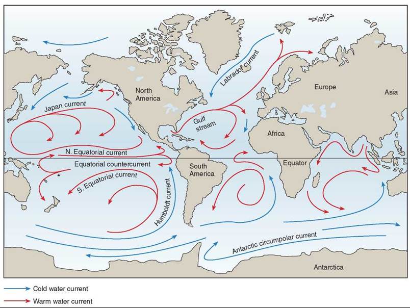
Figure 36.13. Oceanic circulation.
The circulation in the oceans moves in great surface spiral patterns called gyres; oceanic circulation affects the climate on adjacent lands.
Off the western coast of South America, the Humboldt Current carries phosphorus-rich cold water northward up the west coast. Phosphorus is brought up from the ocean depths by the upwelling of cool water that occurs as offshore winds blow from the mountainous slopes that border the Pacific Ocean. This nutrient-rich current helps make possible the abundance of marine life that supports the fisheries of Peru and northern Chile. Marine birds, which feed on these organisms, are responsible for the commercially important, phosphorus-rich guano deposits on the seacoasts of these countries.
El Nino Southern Oscillations and Ocean Ecology
Every Christmas a warm current sweeps down the coast of Peru and Ecuador from the tropics, reducing the fish population slightly and giving local fishers some time off. The local fishers named this Christmas current El Nino (literally, “the child,” after the Christ Child). Scientists have adopted the term El Nino Southern Oscillation (ENSO) to refer to the dramatic version of the same phenomenon, one that occurs every two to seven years and is not only felt locally but on a global scale.
Scientists now have a pretty good idea of what goes on in an El Nino. Normally the Pacific Ocean is fanned by constantly blowing, east-to-west trade winds. These winds push warm surface water away from the ocean’s eastern side (Peru, Ecuador, and Chile) and allow cold water to well up from the depths in its place, carrying nutrients that feed plankton and hence fish. This warm surface water piles up in the west, around Australia and the Philippines, making it several degrees warmer and a meter or so higher than the eastern side of the ocean. But if the winds slacken briefly, warm water begins to slosh back across the ocean (indicated by the darker red band stretching between Australia and the northern coast of South America in figure 36.14), causing an El Nino.
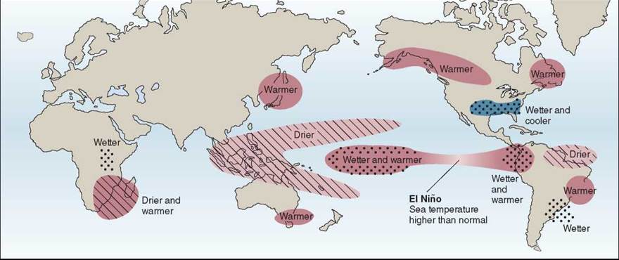
Figure 36.14. Effects of El Nino.
El Nino currents produce unusual weather patterns all over the world as warm waters from the western Pacific move eastward.
We now know that a slight weakening of the trade winds is actually part of a change in wind circulation patterns that recurs irregularly every 2 to 7 years. Once the winds weaken a bit, the eastern ocean warms, and the air above it becomes warmer and lighter. The eastern air becomes more similar to the air on the western side. This reduces the difference in pressure across the ocean. Because a pressure difference is what makes winds blow, the easterly trades weaken further, letting the warm water continue its eastward advance.
The end result is to shift the weather systems of the western Pacific Ocean 6,000 kilometers eastward. The tropical rainstorms that usually drench Indonesia and the Philippines are caused when warm seawater abutting these islands causes the air above it to rise, cool, and condense its moisture into clouds. When the warm water moves east, so do the clouds, leaving the previously rainy areas in drought (indicated by the light pink, hatched areas in figure 36.16). Conversely, the western edge of South America, its coastal waters usually too cold to trigger much rain, gets a soaking (the dotted red areas), while the upwelling slows down because of the warm water. During an El Nino, commercial fish stocks virtually disappear from the waters of Peru and northern Chile, and plankton drops to a twentieth of its normal abundance. The commercially valuable anchovy fisheries of Peru were essentially destroyed by the 1972 and 1997 El Ninos.
That is just the beginning. El Nino’s effects are propagated across the world’s weather systems. Violent winter storms lash the coast of California, accompanied by flooding, and El Nino produces colder and wetter winters than normal in Florida and along the Gulf Coast. The U.S. Midwest experiences heavier than normal rains (the blue dotted area).
La Nina. El Nino is an extreme phase of a naturally occurring climatic cycle, but as in all cycles, there is an opposite side to it. While El Nino is characterized by unusually warm ocean temperatures in the eastern Pacific, La Nina is characterized by unusually cold ocean temperatures in the eastern Pacific. The strengthening of the east-to-west trade winds intensifies the cold upwelling along the eastern Pacific, with coastal water temperatures along the South American coast falling as much as 7°F below normal. Although not as well known as El Nino, La Nina causes equally extreme effects that are nearly opposite to those of El Nino. In the United States, the effects of La Nina are most apparent during the winter months.
Key Learning Outcome 36.8. The world's oceans circulate in huge gyres deflected by continental landmasses. Disturbances in ocean currents like an El Nino and La Nina can have profound influences on world climate.